My Holiday
October 2004 After a stopover at Singapore and Port Moresby I arrived at Kavieng, New Ireland province. From there it took about 20 minutes by boat before arriving at Lissenung Island.
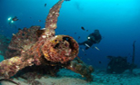
The first three days the weather was not willing to play along as thunderstorms and rainfalls made diving not what I've expected to be. But the fourth day started with a blue sky and sunshine and the real holiday should have started. Unfortunately due to the weather condition I got a cold so diving was still not what I've hoped for. After two days of rest and some extra vitamines I've dived at several places at the Bismarck Sea and the Pacific Ocean. Some highlights were: Ral Island, Matrix and Albatros Passing. The last site was special as the the sharks came real close to me so I was able to film them in close ups.
But not only the "big" stuff was interesting. On Ral Island for example I've done some "muck" diving i.e. seeing real small stuff, thanks to Tommy the dive guide who showed me a lot of small things which I couldn't see by myself. I've dived several times with him and it were all good dives.
All the dives were under supervision of the dive masters Paul and Sue.
I stayed at Lissenung Island Resort. A small but cosy resort. The management of the resort was in the hands of our dive masters Paul and Sue. Their good care and pleasant company made this stay one to remember.
Location
Papua New Guinea is after Greenland the largest island of the world. It lies on the continental plateau of Australia and has a lenght of 2400 km and widht 730 km. The western part belongs to Indonesia (Papua) and the western part belongs since 1973 to the Independent State of Papua New Guinea
The province New Ireland is the most northeastern island of Papua New Guinea. The island lies between one and five degrees south of the equator and belongs to the Bismarck sea, part of the Pacific ocean. Papua New Guinea is part of the region
Melanesian.
Geography
Papua New Guinea is mostly mountainous (highest peak: 4509 m) and covered with rain forest; there are small plains along the coast. Situated along a fault line, earthquakes and the resulting tsunamis are relatively common in Papua New Guinea.
The Province New Ireland is part of the Bismarck Archipelago, and is often described as having the shape of a musket. The tropical island of New Ireland is long, narrow and mountainous. For much of its 320 km length, it is less than 10 km across, yet the central mountainous spine is very steep and rugged. The highest peak is Lambel (2,150 metres or 7,054 feet). The land area of the province is around 9600 square km.
Language
While there exists over 700 languages and dialects in the country, English is the language of business and is widely spoken. Pidgin English is the lingua franca, while Hiri Motu is commonly spoken in the Papuan region.
Climate
Warm to hot and humid throughout the year. There is a rainy season, which varies from province to province, however, in general, it's driest from May to December. The temperature on the coastlines is appx. 79° F (26° C). The avarage rainfall is increasing from east to west from 800 mm to 3500 mm yearly.
Diving conditions
Water temperature is the whole year about 29°C and the underwater visibility is at most dives between 30 and 40 meters. On almost all of the dive sites permanent moorings are used to avoid damage from anchoring. Also a 'no touch'-policy has been introduced. New Ireland is known for the pelagic fish action, but you need currents for attracting big fish. This type of diving is sometimes a bit difficult because of the strong currents (no drift dives!).
Time difference
+9 hrs GMT
